How to Avoid Tolls [Google Maps, Alternate Routes + MORE]
Learn how to avoid tolls with Google Maps step by step. And then see how you can increase route efficiency beyond tolls with route optimization...
Home > Blog > Route Optimization Using Google Maps: Does It Work?
Delivery LogisticsWhen it comes to route planning and logistics, many people talk about route optimization using Google Maps, but does it actually work for delivery?
When it comes to route planning and logistics, many people talk about route optimization using Google Maps, but does it actually work for last-mile delivery?
When we use the term “route optimization,” we mean efficiently solving the problem of route planning and task scheduling.
But when we talk about route optimization software, we are talking about automation of those processes.
In short, route optimization allows you to create the most efficient routes in seconds for the places your drivers need to reach.
That, admittedly, sounds like something that could be achieved simply by using Google Maps.
But, can it?
While Google Maps isn’t route optimization software, but you can still use it to you plan routes.
Google Maps is a navigation tool that can help you find the shortest route from point A to B.
Typically, people use the app to plan trips, create holiday itineraries, or navigate to a specific location.
But you can also add up to 10 destinations. Which means you can use it as a routing app for business, as well.
Usually, companies that use Google Maps to plan routes are those that don’t rely on delivery, transportation, or distribution as an integral part of their service.
And in these situations, the software performs exceptionally well for them since it’s free and easy to use.
So, how do they use it?
Using Google Maps to plan a route is very easy, thanks to Google’s user-friendly interface.
To start Google Maps, you can either enter the URL in your browser (PC) or tap the app on your smartphone to launch it.
On Android, this is straightforward. The app is usually pre-installed and included in the Google package.
On iOS, you have an extra step. You need to visit the Apple Store and install the app before you can launch it from your phone.
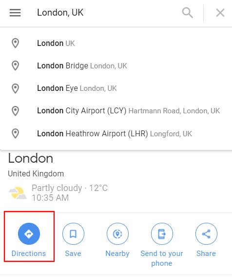
Once you launch Google Maps, you have a search screen where you can enter any location on the planet.
To create a route, you’ll have to click on the Directions button.
Source: Google Maps
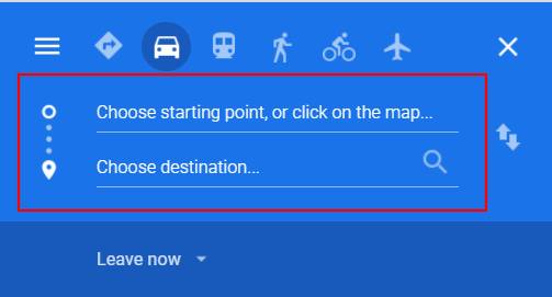
That enables you to input the start and end location in the fields for your route.
Source: Google Maps
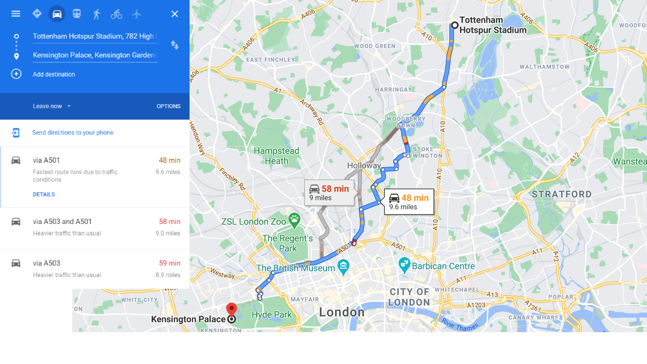
Once you’ve entered the start and end destination, you get something that looks like this:
Source: Google Maps
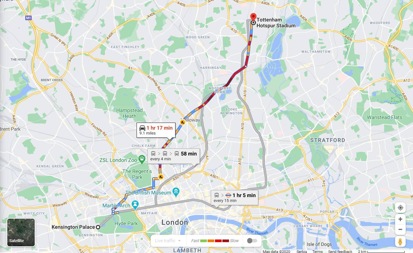
The fastest route is the route highlighted in blue. But you can select an alternative route that is highlighted in grey, as well.
Source: Google Maps
Each route shows you the start/endpoint, estimated distance and time of arrival, markers to specific landmarks, and, thanks to the latest update, even basic traffic patterns you could encounter.
One of the advantages of route planning using Google Maps is that you can add multiple destinations in succession. That enables you to map routes with multiple stops:
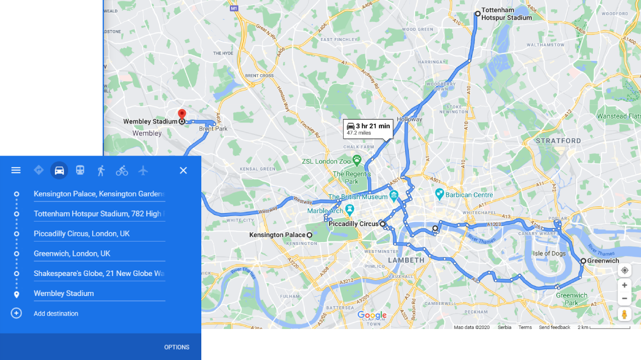
Source: Google Maps
If you use Google Maps on your PC, you can also plan a route in Google Earth and generate a real-world view of the map:
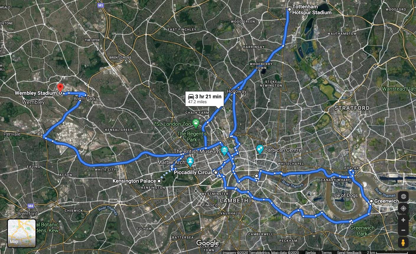
Source: Google Maps
Note: The apps’ latest update now allows you to input or change your starting location, instead of using GPS and geocoding to set the current location of your device as the default start point.
Google Maps is a great way to plan your route, but it may not always give you the exact route you want to take.
But you can change that by selecting one of the grey alternative routes, clicking on them, and dragging them to customize the route.
You also have the option to send your routes by email or SMS, which is especially useful for dispatchers.
Technically, Google Maps can help you plan routes with multiple stops. But it works best for simple route planning since the app calculates routes based on distance.
If you have no more than five stops, the app will only reveal the shortest route without alternative paths. Which makes it difficult to plan the most effective route.
The app was also never designed to automatically and efficiently rearrange stops. Instead, it uses distance to arrange them from the nearest to farthest destination.
So it won’t provide you with optimal multi-stop routes as you would with route optimization software.
Nevertheless, adding multi-stop routes in Google Maps is easy. All you do is click on “Add destination” and input the address of the additional stop:
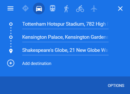
Source: Google Maps
After you enter the new destination, Google Maps automatically generates a new route.
Once you’ve added one stop, you can add another in the empty field below.
Note: You can only have 10 stops
The biggest drawback of Google Maps is that the routes it calculates aren’t always the fastest or best.
You might need to plan a route for several drivers, but the app doesn’t allow you to plan them all at once, nor optimize them based on other factors besides distance.
And, as we’ve mentioned, Google Maps’ multi-stop routes feature is better suited for simple route scenarios, with the least number of destinations.
So, even though you can technically use Google Maps to map routes with multiple destinations, it isn’t quite what you need when you manage a delivery.
Here’s why:
The simple answer is NO. But let’s explain.
Why Google Maps isn’t route optimization software?
If you do a quick search on Google, you’ll find that most SaaS route optimization solutions don’t have a limit on the number of stops you can plan. (At least, in theory.)
In practice, the number of routes, tasks or stops depends on how much you’re willing to pay for route optimization software.
So, you’ll have to know how much does delivery management software cost before you move forward.
The provider limits this by creating different subscription plans. And the package you end up choosing determines the numbers.
But, generally speaking, the software can cover all operational requirements regardless of the size, volume, and use-case.
By comparison, Google Maps allows you to plan routes with up to 10 stops. And you have to plan routes for one driver at a time.
Google Maps focuses more on places. It provides solid navigation and allows you to use it in the same way that a tourist would use a paper map while exploring a city.
With that in mind, it’s clear that Google Maps isn’t intended for commercial route planning, and it’s much more useful for consumers than for businesses.
So, if you require a more in-depth approach to logistics you should rely on professional software for planning delivery routes.
Route optimization software is the most efficient and effective way to plan delivery or service routes.
It lets you calculate the best routes based on a number of different factors on the road (besides distance), including:
But also various operational parameters such as:
Unlike Google Maps, you can plan multiple routes with multiple stops for all the vehicles in your fleet at the same time.
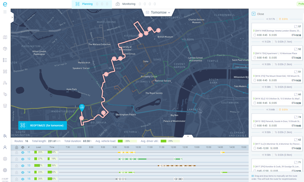
And while the routes in Google Maps stay locked after you create them, route optimization software remains flexible.
The tool allows you to track operations in real-time, and make modifications to routes on the go.
That includes adding or removing stops from the route, rearranging their order, and changing the paths drivers take to reach them.
Plus, the software stores all of your data on the cloud.
So, adopting the cloud-first approach to delivery logistics makes it easier for you to access and import/export routes that your drivers have already used.
Route optimization software is a complex system. It consists of multiple modules (one of which is route planning and optimization).
Each module helps you to manage the different aspects of your logistics operation:
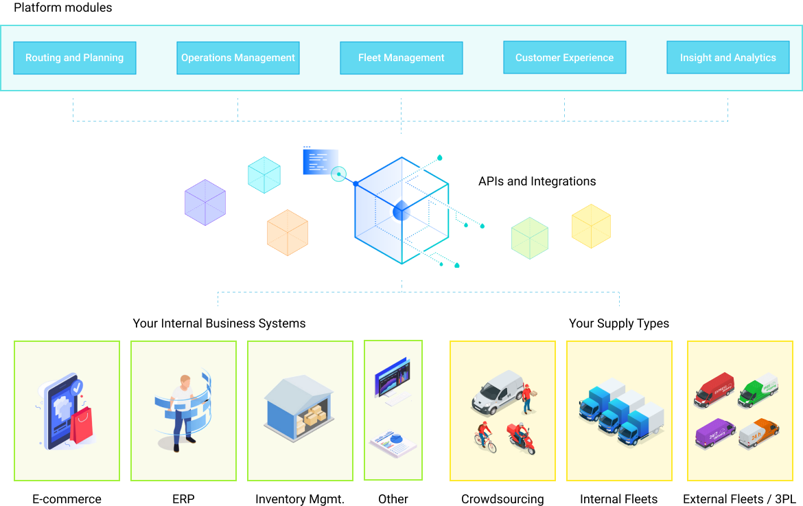
At the same time, each module has its own set of codes and algorithms to perform its intended operation. While all of it integrates into a unified system - route optimization software.
So, the question of whether you should use this type of software is also a question of whether you want to centralize or not to centralize your delivery
As an example, let’s see how eLogii works.
As mentioned, the software also operates on the cloud. So to use it, all you have to do is go to the provider’s website and log into your account.
After that, you’ll gain access to the main platform (also called the dashboard).
The dashboard is your central control panel from where you customize the parameters of each module before planning routes and scheduling deliveries.
For example, you can build profiles for your drivers, import deliveries via .csl files, set up and plan single or multi-depot locations.
Setting up depot locations:
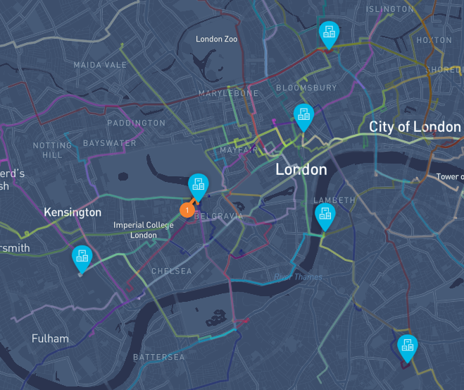
Creating driver profiles:
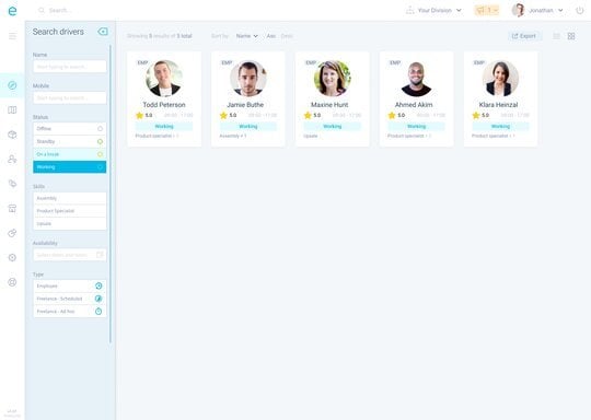
After you’ve added all of the operational data for a specific date, all you do is click the Optimize button to initiate the route optimization.
After a few seconds, you’ll have the routes for all your vehicles visible on the screen:
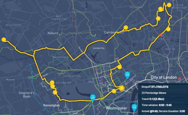
The system automatically assigns the deliveries to different drivers and divides all of the stops to each route for maximum efficiency and route density.
Route density:
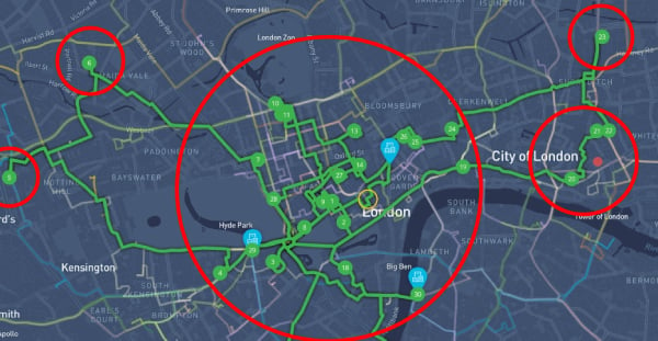
That helps to reduce the cost per delivery and minimize the resources (fuel, time, money) necessary to complete each task.
And as you collect more data, recurring route optimization allows you to dynamically select the ideal delivery routes, for the right driver every time.
Like route planning and route optimization are different from one another, so too are Google Maps and route optimization software.
In this part of the article, we’ll highlight their main differences.
Specifically, you’ll see the limits of Google Maps through the key features of route optimization software. And what particular problems you can’t expect it to solve.
Let’s start.
Earlier, we mentioned Google Maps has a multi-stop feature.
Don’t confuse this with the multi-routes features of route optimization software.
The difference between multi-stops and multi-routes lies in the name itself:
You can only use Google Maps to map multiple destinations, but you can’t simultaneously create multiple routes. You have to do it one route at a time.
On the other hand, route optimization software lets you do this all at once, automatically, and for all of your vehicles/drivers and delivery stops.
Route optimization software allows you to create routes according to certain constraints. Google Maps doesn’t.
We’ve mentioned these factors, but the parameters go beyond that.
Technically, there is a route optimization Google Maps API that includes:
But, Google Maps APIs are limited.
For example, you can connect it with a third-party traffic tracking app to gain real-time updates about traffic congestion. But you have to manually plan the route based on those updates.
By contrast, you can use a route optimization software API to connect it to a variety of different third-party solutions.
That can include traffic tracking apps, but also order management systems, supply chain management software, and other logistics solutions.
The best part about this is that you can view and use all of this third-party data directly on the dashboard. Which includes adding different parameters before planning and optimizing your routes.
Planning an optimal stop order helps you to plan better delivery schedules.
But unlike route optimization software, Google Maps doesn’t have this function.
Instead, it arranges the stops based on distance, which isn’t always a key factor when planning deliveries.
Add to that the limit of just 10 stops per route, and Google Maps is only suitable for businesses that don’t overly rely on delivery.
And since the state of delivery in time of the coronavirus has changed the nature of retail, it isn’t a good enough solution for most businesses in 2020.
If you take into account that Google Maps wasn’t intended as a delivery optimization tool, the fact you can’t manage other aspects of delivery (apart from routing) is a major disadvantage.
So, while you may save money on a routing software, you’ll still need to invest in other software.
And how much money are you really saving with all of Google Maps limited capabilities?
Not much. But the problem goes beyond that.
Building an agile delivery relies on quick and accurate decision-making. And decisions are only as accurate as is the information they rely on.
Without an end-to-end solution, like route optimization software, you can’t have complete visibility over your delivery.
At the same time, that also prevents you from analyzing the performance of your delivery and making data-driven decisions.
Likewise, it prevents you from finding opportunities to improve the operation, reduce the waste of resources, and actually reduce the cost of delivery.
If you are a business that relies on delivery in any way, Google Maps simply can’t cut it.
But if you’re not convinced yet, here are some additional benefits to help you decide:
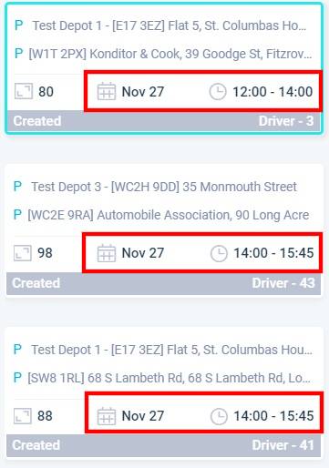
By enabling you to plan routes with delivery time windows and dates, the tool can help you to additionally optimize your operations.
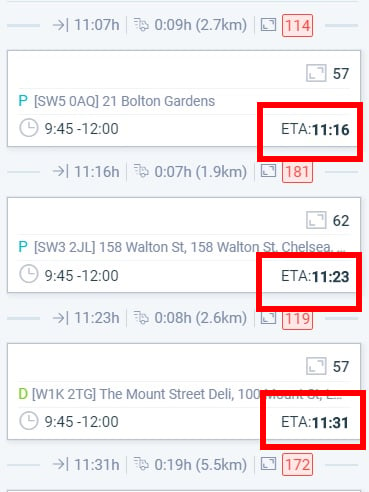
You can add the exact date and time for each delivery, which means the software can calculate routes based on optimal arrival times. (And not only distance like Google Maps)
Date and time of delivery:
Estimated time of arrival:
It also means that you can plan multiple routes for multiple vehicles, but also for multiple dates.
That means you can schedule all deliveries ahead of time, and allow route planners to focus on other areas of your delivery operations.
Route optimization software also lets you add vehicle and driver information, and make it relevant when planning delivery routes.
For example, you can add vehicle capacity when building your fleet in the program. That can help you determine what tasks to assign to those vehicles, while the software can limit the number of stops a specific vehicle can perform.
At the same time, some drivers are better equipped or suited to cover different delivery areas.
Vehicle route optimization enables you to assign drivers to specific tasks, routes, vehicles, and even customers based on their history and performance details.
What if your company offers multiple delivery options (e.g. same-day delivery vs. 5-day delivery)?
You can’t use Google Maps to plan routes because the delivery doesn’t rely on distance as much as it relies on time and the delivery schedule.
Route optimization software solves this by allowing you to input data about the delivery itself.
You can add time stamps, order priority, type of task, timeframe, and anything else you need to create a delivery schedule.
You can then use the software to calculate the best route according to the schedule, which ensures on-time delivery, order accuracy, and other key metrics in delivery logistics remain high.
For business owners, route optimization is about identifying the most efficient route in terms of cost, resources, and time.
It is about planning one or more routes to minimize the overall cost by achieving the highest possible performance within a range of given constraints.
Knowing the best routes for the most efficient delivery times helps you reduce fuel costs, deliver more orders with the same number of vehicles, and make the delivery process more efficient overall.
And that can help you to improve last-mile delivery when demand exceeds your capacity.
Good route optimization software accomplishes all of this quickly and gives you more time to focus on other vital aspects of your business.
We have everything you need to start improving your delivery.
Learn how to avoid tolls with Google Maps step by step. And then see how you can increase route efficiency beyond tolls with route optimization...
Looking for a route optimization solution for your business? Here are 7 essential components you mustn’t overlook if you want the best route planner.
See how to plan a route with multiple stops on Google Maps (step by step) and why avoid it when planning delivery routes + Use Cases and more.
Be the first to know when new articles are released. eLogii has a market-leading blog and resources centre designed specifically to help business across countless distribution and field-services sub sectors worldwide to succeed with actionable content and tips.
